
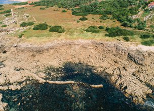
Morgado fishing ground
Fishing grounds, created by humans, are elements of the maritime and fluvial heritage, and are fisheries built along the beach line in rocky outcrops, used to reinforce these structures.
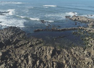
Fishing grounds are enclosed by stone walls that are submerged in the high tide, when the tide lowers the water drains along with the small fish and other species of small growth, through nets (“tranqueira” or “trancadas”) placed on a door, called “broeira”, open on the water side, retaining the most grown fish.
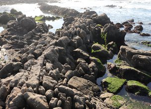
In general, fishing ground’s walls or “encirclement” were built using natural rock, where the stones were carved in successive layers (figure 1), thus giving more resistance to its walls.
The Morgado fishing ground is part of the collection of dozens of fishing grounds preserved in the territory of this Geopark, it has an area of approximately 1,000 m² and its stone wall measures about 51 m in length.
In the North of Portugal the fishing grounds existed since the Middle Ages, but the first documented references to fishing grounds of the then “Viana da Foz do Lima” (now Viana do Castelo), were made in the inquiries of D. Afonso III, from 1258 (“… Cambôa pedrina daan al rey o melior peixe…”), and arrived as real estate until 1940. This year, the Portuguese legislation for the protection of target species of fishing, considers fishing grounds to be illegal because they do not allow selective catches, and orders their demolition, leading to its extinction, currently leaving only traces of this activity.
Depending on the distance they are from the beach and the area they occupy, fishing grounds can be classified into three distinct groups: named “Cegas”, the fishing grounds located in areas of greater depth, the “Caxuxos” with smaller dimensions and the fishing groundsthemselves, of great dimensions.
References:
Carvalhido (2012). O Litoral Norte de Portugal (Minho-Neiva): evolução paleoambiental quaternária e proposta de conservação do património geomorfológico. Tese de Doutoramento, Universidade do Minho, 564 p.
Carvalhido, R.; Brilha, J. & Pereira, D. (2014a) – Monumentos Naturais Locais de Viana do Castelo: processo de classificação e estratégias de valorização. Comunicações Geológicas (2014) 101, Especial III, 1219–1223.
Carvalhido, Ricardo (2014b). Processo de classificação dos 5 Monumentos Naturais Locais de Viana do Castelo. Memória Descritiva. Câmara Municipal de Viana do Castelo.
Fishing grounds, created by humans, are elements of the maritime and fluvial heritage, and are fisheries built along the beach line in rocky outcrops, used to reinforce these structures.
Fishing grounds are enclosed by stone walls that are submerged in the high tide, when the tide lowers the water drains along with the small fish and other species of small growth, through nets (“tranqueira” or “trancadas”) placed on a door, called “broeira”, open on the water side, retaining the most grown fish.
In general, fishing ground’s walls or “encirclement” were built using natural rock, where the stones were carved in successive layers (figure 1), thus giving more resistance to its walls.
The Morgado fishing ground is part of the collection of dozens of fishing grounds preserved in the territory of this Geopark, it has an area of approximately 1,000 m² and its stone wall measures about 51 m in length.
In the North of Portugal the fishing grounds existed since the Middle Ages, but the first documented references to fishing grounds of the then “Viana da Foz do Lima” (now Viana do Castelo), were made in the inquiries of D. Afonso III, from 1258 (“… Cambôa pedrina daan al rey o melior peixe…”), and arrived as real estate until 1940. This year, the Portuguese legislation for the protection of target species of fishing, considers fishing grounds to be illegal because they do not allow selective catches, and orders their demolition, leading to its extinction, currently leaving only traces of this activity.
Depending on the distance they are from the beach and the area they occupy, fishing grounds can be classified into three distinct groups: named “Cegas”, the fishing grounds located in areas of greater depth, the “Caxuxos” with smaller dimensions and the fishing groundsthemselves, of great dimensions.
References:
Carvalhido (2012). O Litoral Norte de Portugal (Minho-Neiva): evolução paleoambiental quaternária e proposta de conservação do património geomorfológico. Tese de Doutoramento, Universidade do Minho, 564 p.
Carvalhido, R.; Brilha, J. & Pereira, D. (2014a) – Monumentos Naturais Locais de Viana do Castelo: processo de classificação e estratégias de valorização. Comunicações Geológicas (2014) 101, Especial III, 1219–1223.
Carvalhido, Ricardo (2014b). Processo de classificação dos 5 Monumentos Naturais Locais de Viana do Castelo. Memória Descritiva. Câmara Municipal de Viana do Castelo.

Location
Montedor, Carreço
Coordinates
Lat: 41.7484075
Long: -8.8780308
 Theme
Theme
 Point of interest

Hello little one!
I'm Piquinhos and I can help you learn more about the Geopark!

Technical details
Child Mode
Discover the geopark in a simpler format, aimed at the little ones.
Clique ENTER para pesquisar ou ESC para sair