
From the source to the mouth
This Natural Monument is located in a section of Âncora river. Its source is 805 m high, in Arga Mountain, and it flows into the ocean near Vila Praia de Âncora after a 21 km journey. The Âncora hydrographic basin, with an area of 77 km², lies between the Minho basin to the north and the Lima basin to the south (esq. A).
Cascades and other types of waterfalls
A waterfall is a sudden break in the slope of a riverbed. In what concerns the shape, there are various types of waterfalls: cascades, cataracts, plunge, block, punchbowl, among others.
A cascade is a particular type of waterfall presenting several steps naturally excavated in the rock which are originated by water erosion.
Cataracts are typically wider than tall and discharge a large volume of water. In plunge waterfalls, water falls without contacting the rock. In block waterfalls, the rock surface from which the water falls is wide. In a punchbowl, the water goes down along a narrow channel and is collected in a basin.
How waterfalls form?
The sudden break in the slope of a riverbed waterfall is associated with erosion which is related with certain characteristics such as (esq. B):
- the different strength of the rocks;
- the occurrence of faults and other tectonic movements; - sea level changes;
- the melting of glacier ice.
Ferida Má Cascades is 2.25 km long, between Montaria and Amonde, presents a high slope (7,6%), between 260 and 90 m of high, and is 15 m far from the coastline. Upstream, on the granite western flank of Arga Mountain, the slope is even more pronounced but downstream it becomes quite gentle (esq. C).
References:
Pereira, P; Henriques, R.; Brilha, J. & Pereira, D.I. (2019). Conteúdos científicos para a caracterização dos 8 monumentos naturais locais” enquadrado no projeto Geoparque Litoral de Viana do Castelo – 2ª fase. Município de Viana do Castelo, Relatório Final GEOSITE, 273 p.

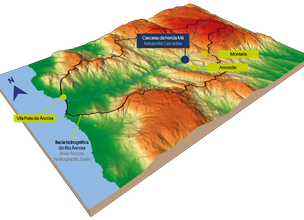
Esq. A - Âncora hydrographic basin and location of Ferida Má Cascades Local Natural Monument
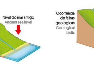
Esq. B - Different ways of waterfall formation
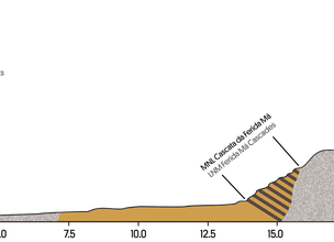
Esq. C - Âncora river profile.
Location
Montaria
Coordinates
Lat: 41.796742
Long: -8.7333645
 Theme
Theme
 Point of interest

Hello little one!
I'm Piquinhos and I can help you learn more about the Geopark!

Technical details
Esq. A - Âncora hydrographic basin and location of Ferida Má Cascades Local Natural Monument
Esq. B - Different ways of waterfall formation
Esq. C - Âncora river profile.
Child Mode
Discover the geopark in a simpler format, aimed at the little ones.
Clique ENTER para pesquisar ou ESC para sair