
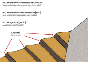
The diversity of forms and formation processes of waterfalls
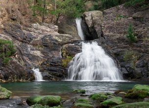
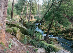
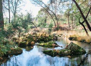
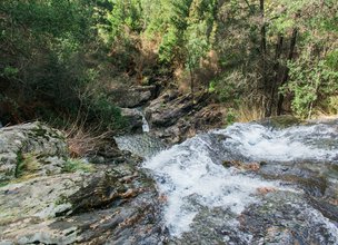
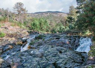
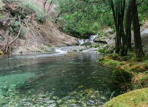
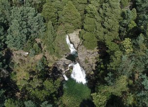
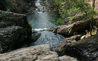
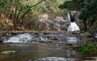
The Natural Monument corresponds to the section of the Âncora River (bed and margins), between Montaria and Amonde (36 ha). In addition to the great landscape value of the site, materialized in the good recognition and appeal that the area has for the tourist industry, the geosite preserves two subunits of the Central Minho Unit metasiltstone and metapelites of the Arga-allochthon subunit; gray schists and quartzites of the Torre-Amonde-parautóctone subunit; Meireles et al., 2014), and it is also an important area in understanding the polyphasic character of the formation of asymmetric boudins (sheared quartz vein a stacked-fold-boudin; cf. Pamplona & Rodrigues, 2011) . The area to be classified preserves several waterfalls with a difference of more than 5 m and wells (lagoons). The inflection of the course, in the upstream sector, north of Espantar, derives from fault control (Meireles et al., 2014). Carvalhido et al. (2014)
References:
Carvalhido, R., Brilha, J. & Pereira, P. (2014). Monumentos Naturais Locais de Viana do Castelo: processo de classificação e estratégias de valorização. Comunicações Geológicas (2014) 101, Especial III, 1219-1223
Meireles, C.; Pamplona, J. & Castro, P. (2014). Lito e tectono-estratigrafia da Unidade do Minho Central e Ocidental: uma proposta de reclassificação. Comunicações Geológicas (2014) 101, Especial I, 269-273.
Pamplona, J. & Rodrigues, B. (2011). Kinematic interpretation of shearband boudins: new parameters and ratios useful in HT simple shear zones. Journal of Structural Geology 33, 38-50.
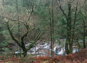
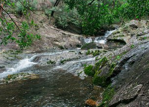

Ferida Má Cascades profile
Location
Âncora River section (bed and banks) between Montaria and Amonde
Coordinates
Lat: 41.7995234
Long: -8.7414196
 Theme
Theme
 Point of interest
Themes
Discover all the themes of Ferida Má Cascades

Ecological Recovery
The following proposal was presented by the Mayor of the Chamber:- "PROPOSAL - Cooperation Protocol within the scope of the Progama de Reabilitação de Áreas Classificadas do concelho de Viana do Castelo - Responsabilidade ambiental no âmbito das áreas classificadas do concelho de Viana do Castelo".
In the scope of the Municipal Strategy for Nature Conservation, a plan inscribed in the ongoing Environment and Biodiversity Agenda for the four-year period 2017-2021, the Municipality prepared the Programa de Reabilitação Ecológica das Áreas Classificadas do concelho, in this first phase, focusing on 5 of the 13 Natural Monuments, unique areas for the knowledge of the geological history of the Iberian Peninsula since more than 500 million years ago and which are part of the application that the Municipality is preparing for recognition as a UNESCO World Geopark territory. Viana do Castelo is a rich territory from the point of view of Natural and Cultural Heritage, with about 4,800 hectares specifically designated for the protection of fauna and flora habitats (3 sites of Community importance of Natura 2000 Network), being the only municipality in the country with the geological heritage inventory concluded and duly classified with 13 natural monuments, making up a total area of about 2,832 hectares. The recovery programme that was drawn up supported an application to PO SEUR, with approval of the overall investment amount of 500,000 euros, financed at 85%, with implementation in 2020 and 2021. The ecological recovery interventions that are intended to be carried out include actions to eradicate and control exotic species, mainly Acacia dealbata (Mimosa), Acacia longifolia (Acacia longifolia) and Acacia Melanoxylon (Australia), Carpobrotus edulis (beach weevil), Arundo donax (giant reed), Trandescantia fluminencis (Fortune grass or tradescância) and Cortaderia selloana (pampas grass or plumas). In addition to these actions, supported by an exhaustive inventory carried out by the Municipality for those species, the programme includes actions to promote scientific literacy to the population and the densification of the Municipality's Citizen Science strategy, extending the Bioregisto platform to the cartography of invasive vegetation, in collaboration with the Functional Ecology Centre of the University of Coimbra (invasoras.pt). In addition, planting actions are planned in the areas to be ecologically intervened, namely native species such as oak, pine, hawthorn, holm oak, birch or heather, among others, within the scope of the Municipal Year for the Recovery of Portuguese Native Forests, currently underway. In order to guarantee the perennial success of the intervention and the investment made, the rehabilitation programme foresees the involvement of the social and business fabric, and within the scope of the environmental responsibility of the institutions, so that they may take responsibility for the maintenance of the ecological quality of all or parts of the classified areas of the municipality of Viana do Castelo. The programme for the ecological rehabilitation of the classified areas of Viana do Castelo - 1st phase - was carried out with the collaboration of the Parish Councils of Afife, Carreço, Darque, Vila Nova de Anha and Santa Marta de Portuzelo, and also with the Parish Councils of Mazaferes and Vila Fria and the Parish Councils of Viana do Castelo (Santa Maria Maior and Monserrate) and Meadela. The Associação de Caçadores de Vila Nova de Anha and the Comissão Diretiva dos Baldios da Montaria were also partners.


Hello little one!
I'm Piquinhos and I can help you learn more about the Geopark!

Technical details
Ferida Má Cascades profile
Child Mode
Discover the geopark in a simpler format, aimed at the little ones.
Clique ENTER para pesquisar ou ESC para sair