
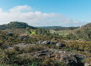
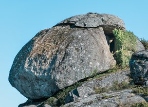
Granitic rocks and granitic landforms.
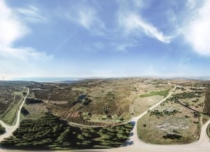
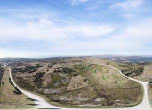
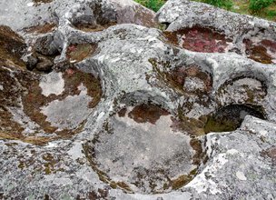
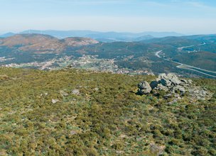
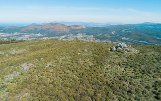
Accordingly to Carvalhido (2012, 2014) this Local Natural Monument geosite corresponds to an area of about 908 ha, constituted to the north by the Chã de Afife, to the east by the Chã da Gurita de Couço and to the south, by the Chãs de Carreço and Areosa. The western limit of the geosite coincides, roughly, with the Atlantic slope of the Serra de Santa Luzia. From the geocultural interest point of view, they refer to the conservation of inscultures, namely fossets and quadriláteros, which are manifestations of litholatry (Bronze age?) Or will be much later, consisting of parish limits or support for games practiced by pastors. There is still no consensus on the age and significance of these engravings (Almeida, 1981; Abreu, 2009). From a geomorphological point of view, the geosite constitutes the flattening surface at the top of the Santa Luzia mountain range, which develops essentially at 460 meters (eg Santa Luzia, 550 m). This surface constitutes the culminating surface of the Caminha-Viana do Castelo antiform. Residual geoforms such as the inselberg (eg. bornhardt dorso-de-baleia, in Chã de Afife) and the largest scale, the pothole, are relics of the subaerial evolution stage of granite terrain, prior to the erosion of the regolith. The exutories that were identified associated with the potholes, prove that these structures were probably recovered during the post-exhumation stages of the terrain, in the domain of the processes of slope dynamics. There are several outcrops with swarms of surmicaceous and biotitic enclaves with tourmaline, relic testimonies of the dome position of the Bouça de Frade pluton in relation to the metasedimentary embedding.
In the area of Covões and according to Lima (2006) the gradual contact of the plutons of Bouça de Frade and Afife occurs, with some pegmatitic differences due to their structure and mineralogy. These bodies are philonian and assume variable outcropping (up to ~ 1 m) and north-south subvertical altitudes. Presenting as interesting mineral accessories are automorphic garnet, tourmaline and beryl. This geosite is part of the Lavarias Romeiras de Santa Luzia geosite, which is an area where hydrogravitic separation of Sn (cassiterite), rutile, ilmenite-rutile and ilmenite was carried out in basins and gutters. This activity was generally carried out by women and children, on a seasonal basis, namely in the rainy seasons and periods.
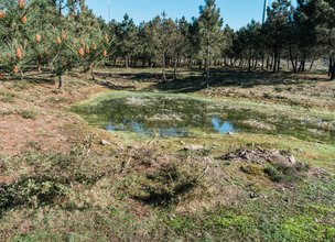
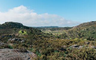
The geosite is an area of great landscape and ecological value, the latter patent, for example, in the biological communities installed in the lagoons and streams formed as a result of local emergencies (Chã de Carreço).
References:
Carvalhido, R.; Brilha, J. & Pereira, D. (2014). Monumentos Naturais Locais de Viana do Castelo: processo de classificação e estratégias de valorização. Comunicações Geológicas (2014) 101, Especial III, 1219–1223.
Carvalhido, Ricardo (2012).O Litoral Norte de Portugal (Minho-Neiva) : evolução paleoambiental quaternária e proposta de conservação do património geomorfológico. Tese de Doutoramento. Universidade do Minho. 564 p.
Lima, M. F. (2006). Caracterização e estratégias de valorização sustentável de ocorrências geológicas com importância patrimonial. Tese de Doutoramento, Universidade do Minho.
Almeida, C. F. (1981). Território paroquial no Entre-Douro-e-Minho: sua sacralização. Nova Renascença, Porto, 1 (2), p.202-212.
Abreu, A. (2009). História de Viana do castelo, Câmara Municipal, 1, 61-65.
Accordingly to Carvalhido (2012, 2014) this Local Natural Monument geosite corresponds to an area of about 908 ha, constituted to the north by the Chã de Afife, to the east by the Chã da Gurita de Couço and to the south, by the Chãs de Carreço and Areosa. The western limit of the geosite coincides, roughly, with the Atlantic slope of the Serra de Santa Luzia. From the geocultural interest point of view, they refer to the conservation of inscultures, namely fossets and quadriláteros, which are manifestations of litholatry (Bronze age?) Or will be much later, consisting of parish limits or support for games practiced by pastors. There is still no consensus on the age and significance of these engravings (Almeida, 1981; Abreu, 2009). From a geomorphological point of view, the geosite constitutes the flattening surface at the top of the Santa Luzia mountain range, which develops essentially at 460 meters (eg Santa Luzia, 550 m). This surface constitutes the culminating surface of the Caminha-Viana do Castelo antiform. Residual geoforms such as the inselberg (eg. bornhardt dorso-de-baleia, in Chã de Afife) and the largest scale, the pothole, are relics of the subaerial evolution stage of granite terrain, prior to the erosion of the regolith. The exutories that were identified associated with the potholes, prove that these structures were probably recovered during the post-exhumation stages of the terrain, in the domain of the processes of slope dynamics. There are several outcrops with swarms of surmicaceous and biotitic enclaves with tourmaline, relic testimonies of the dome position of the Bouça de Frade pluton in relation to the metasedimentary embedding.
In the area of Covões and according to Lima (2006) the gradual contact of the plutons of Bouça de Frade and Afife occurs, with some pegmatitic differences due to their structure and mineralogy. These bodies are philonian and assume variable outcropping (up to ~ 1 m) and north-south subvertical altitudes. Presenting as interesting mineral accessories are automorphic garnet, tourmaline and beryl. This geosite is part of the Lavarias Romeiras de Santa Luzia geosite, which is an area where hydrogravitic separation of Sn (cassiterite), rutile, ilmenite-rutile and ilmenite was carried out in basins and gutters. This activity was generally carried out by women and children, on a seasonal basis, namely in the rainy seasons and periods.
The geosite is an area of great landscape and ecological value, the latter patent, for example, in the biological communities installed in the lagoons and streams formed as a result of local emergencies (Chã de Carreço).
References:
Carvalhido, R.; Brilha, J. & Pereira, D. (2014). Monumentos Naturais Locais de Viana do Castelo: processo de classificação e estratégias de valorização. Comunicações Geológicas (2014) 101, Especial III, 1219–1223.
Carvalhido, Ricardo (2012).O Litoral Norte de Portugal (Minho-Neiva) : evolução paleoambiental quaternária e proposta de conservação do património geomorfológico. Tese de Doutoramento. Universidade do Minho. 564 p.
Lima, M. F. (2006). Caracterização e estratégias de valorização sustentável de ocorrências geológicas com importância patrimonial. Tese de Doutoramento, Universidade do Minho.
Almeida, C. F. (1981). Território paroquial no Entre-Douro-e-Minho: sua sacralização. Nova Renascença, Porto, 1 (2), p.202-212.
Abreu, A. (2009). História de Viana do castelo, Câmara Municipal, 1, 61-65.

Location
Serra de Sta. Luzia
Coordinates
Lat: 41.784102
Long: -8.8268393
 Theme
Theme
 Point of interest
Themes
Discover all the themes of Granite Plateau of Chãs de Sta Luzia

Ecological Recovery
The following proposal was presented by the Mayor of the Chamber:- "PROPOSAL - Cooperation Protocol within the scope of the Progama de Reabilitação de Áreas Classificadas do concelho de Viana do Castelo - Responsabilidade ambiental no âmbito das áreas classificadas do concelho de Viana do Castelo".
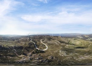
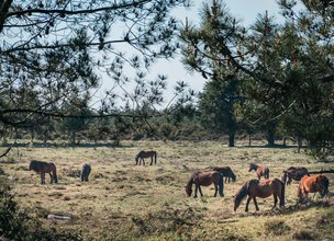
In the scope of the Municipal Strategy for Nature Conservation, a plan inscribed in the ongoing Environment and Biodiversity Agenda for the four-year period 2017-2021, the Municipality prepared the Programa de Reabilitação Ecológica das Áreas Classificadas do concelho, in this first phase, focusing on 5 of the 13 Natural Monuments, unique areas for the knowledge of the geological history of the Iberian Peninsula since more than 500 million years ago and which are part of the application that the Municipality is preparing for recognition as a UNESCO World Geopark territory. Viana do Castelo is a rich territory from the point of view of Natural and Cultural Heritage, with about 4,800 hectares specifically designated for the protection of fauna and flora habitats (3 sites of Community importance of Natura 2000 Network), being the only municipality in the country with the geological heritage inventory concluded and duly classified with 13 natural monuments, making up a total area of about 2,832 hectares. The recovery programme that was drawn up supported an application to PO SEUR, with approval of the overall investment amount of 500,000 euros, financed at 85%, with implementation in 2020 and 2021. The ecological recovery interventions that are intended to be carried out include actions to eradicate and control exotic species, mainly Acacia dealbata (Mimosa), Acacia longifolia (Acacia longifolia) and Acacia Melanoxylon (Australia), Carpobrotus edulis (beach weevil), Arundo donax (giant reed), Trandescantia fluminencis (Fortune grass or tradescância) and Cortaderia selloana (pampas grass or plumas). In addition to these actions, supported by an exhaustive inventory carried out by the Municipality for those species, the programme includes actions to promote scientific literacy to the population and the densification of the Municipality's Citizen Science strategy, extending the Bioregisto platform to the cartography of invasive vegetation, in collaboration with the Functional Ecology Centre of the University of Coimbra (invasoras.pt). In addition, planting actions are planned in the areas to be ecologically intervened, namely native species such as oak, pine, hawthorn, holm oak, birch or heather, among others, within the scope of the Municipal Year for the Recovery of Portuguese Native Forests, currently underway. In order to guarantee the perennial success of the intervention and the investment made, the rehabilitation programme foresees the involvement of the social and business fabric, and within the scope of the environmental responsibility of the institutions, so that they may take responsibility for the maintenance of the ecological quality of all or parts of the classified areas of the municipality of Viana do Castelo. The programme for the ecological rehabilitation of the classified areas of Viana do Castelo - 1st phase - was carried out with the collaboration of the Parish Councils of Afife, Carreço, Darque, Vila Nova de Anha and Santa Marta de Portuzelo, and also with the Parish Councils of Mazaferes and Vila Fria and the Parish Councils of Viana do Castelo (Santa Maria Maior and Monserrate) and Meadela. The Associação de Caçadores de Vila Nova de Anha and the Comissão Diretiva dos Baldios da Montaria were also partners.
The following proposal was presented by the Mayor of the Chamber:- "PROPOSAL - Cooperation Protocol within the scope of the Progama de Reabilitação de Áreas Classificadas do concelho de Viana do Castelo - Responsabilidade ambiental no âmbito das áreas classificadas do concelho de Viana do Castelo".
In the scope of the Municipal Strategy for Nature Conservation, a plan inscribed in the ongoing Environment and Biodiversity Agenda for the four-year period 2017-2021, the Municipality prepared the Programa de Reabilitação Ecológica das Áreas Classificadas do concelho, in this first phase, focusing on 5 of the 13 Natural Monuments, unique areas for the knowledge of the geological history of the Iberian Peninsula since more than 500 million years ago and which are part of the application that the Municipality is preparing for recognition as a UNESCO World Geopark territory. Viana do Castelo is a rich territory from the point of view of Natural and Cultural Heritage, with about 4,800 hectares specifically designated for the protection of fauna and flora habitats (3 sites of Community importance of Natura 2000 Network), being the only municipality in the country with the geological heritage inventory concluded and duly classified with 13 natural monuments, making up a total area of about 2,832 hectares. The recovery programme that was drawn up supported an application to PO SEUR, with approval of the overall investment amount of 500,000 euros, financed at 85%, with implementation in 2020 and 2021. The ecological recovery interventions that are intended to be carried out include actions to eradicate and control exotic species, mainly Acacia dealbata (Mimosa), Acacia longifolia (Acacia longifolia) and Acacia Melanoxylon (Australia), Carpobrotus edulis (beach weevil), Arundo donax (giant reed), Trandescantia fluminencis (Fortune grass or tradescância) and Cortaderia selloana (pampas grass or plumas). In addition to these actions, supported by an exhaustive inventory carried out by the Municipality for those species, the programme includes actions to promote scientific literacy to the population and the densification of the Municipality's Citizen Science strategy, extending the Bioregisto platform to the cartography of invasive vegetation, in collaboration with the Functional Ecology Centre of the University of Coimbra (invasoras.pt). In addition, planting actions are planned in the areas to be ecologically intervened, namely native species such as oak, pine, hawthorn, holm oak, birch or heather, among others, within the scope of the Municipal Year for the Recovery of Portuguese Native Forests, currently underway. In order to guarantee the perennial success of the intervention and the investment made, the rehabilitation programme foresees the involvement of the social and business fabric, and within the scope of the environmental responsibility of the institutions, so that they may take responsibility for the maintenance of the ecological quality of all or parts of the classified areas of the municipality of Viana do Castelo. The programme for the ecological rehabilitation of the classified areas of Viana do Castelo - 1st phase - was carried out with the collaboration of the Parish Councils of Afife, Carreço, Darque, Vila Nova de Anha and Santa Marta de Portuzelo, and also with the Parish Councils of Mazaferes and Vila Fria and the Parish Councils of Viana do Castelo (Santa Maria Maior and Monserrate) and Meadela. The Associação de Caçadores de Vila Nova de Anha and the Comissão Diretiva dos Baldios da Montaria were also partners.


Hello little one!
I'm Piquinhos and I can help you learn more about the Geopark!

Technical details
Child Mode
Discover the geopark in a simpler format, aimed at the little ones.
Clique ENTER para pesquisar ou ESC para sair