
Mineral deposits and geomining heritage
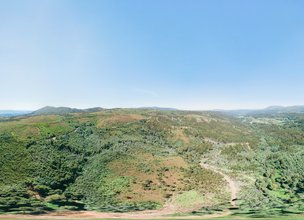
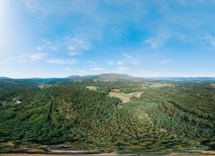
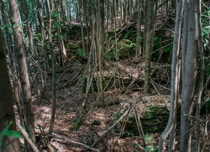
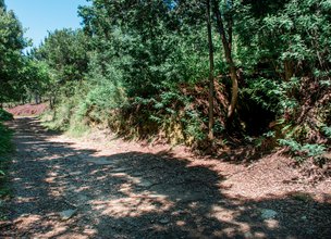
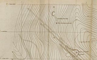
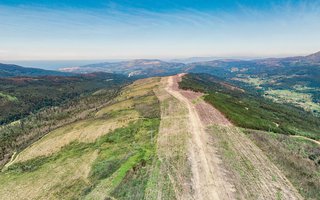
Accordingly to Carvalhido (2016) this natural monument is established between the e.g. Folgadoiro and the Serra de Amonde mountain range to the west (1025 ha). It is a key area for observing the Santa Luzia, Perre and Arga massifs, namely the conserved oddments of the main flattening surfaces. The area consists of two geosites: the Campo Mineiro de Folgadoiro-Verdes geosite and the Mina de Cassiterite do Rexisco. Regarding the first geosite (the area of the natural monument extends to the Alto da Bouça da Breia and Campo da Corte, Serra de Amonde concessions, the Alto de Bouça da Breia Mine (Alto da Bouça da Breia and Folgadoiro) with activity, according to Alves (2014) on 9 philonian bodies, one of which is hydrothermal quartz, with significant W and Au contents, the rest being mineralized by Cassiterite. Ancient excavations on the area of this concession have been recognized, attributed to Roman labor (eg. Roman wells). In addition to the relevant mining heritage, with geocultural, mineralogical and petrographic interest, the residual terrains of the quartzite ridges of the Serra de Amonde, and with tectonic interest, the Carreamento de Vila Verde (parautochtonous-autochthonous sole thrust) are highlighted.
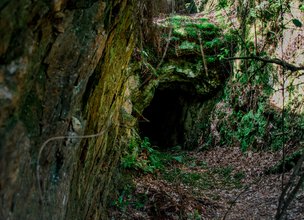
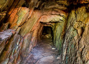
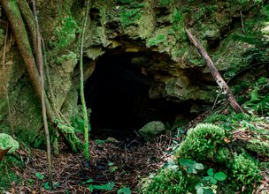
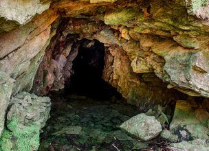
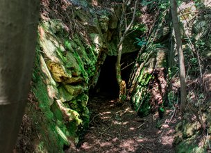
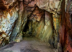
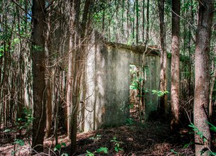
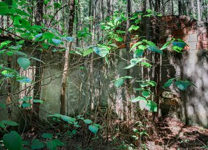
The geosite of the Cassiterite do Rexisco Mine corresponds to the Tourim Mine (concession in 1947), at the Tourim-Amonde site, recognizing extractive activity in this sector since the Roman period (Alto da Bouça da Breia - Folgadoiro - Folgadoura and Campo da Corte). It constitutes a mine with two subperpendicular galleries, one with about 120 m (N-S) and another (E-W, unknown extension), developed on two floors. The mine is carved in rock, without shoring. The mine mouths are closed (railing and / or rubble) to prevent unregulated access. Sn ore (Cassiterite) was extracted from the mine, but also gold installed in hydrothermal veins and hydraulic gaps, which are recognized on the walls of the galleries. They are galleries of unusual beauty, an example of a rare mining heritage and in excellent condition, which needs to be classified and rehabilitated for scientific, tourist and educational use. In the geosite area, there are outcrops of the Central Minho Unit (Torre-Amonde) of gray shales with alternating metassiltites and phyllites, with sulfides (Silurian) (Meireles et al., 2014).
References:
Carvalhido (2016). Memória descritiva sobre os interesses geológicos conservados nos geossítios propostos para classificação. Câmara Municipal de Viana do Castelo.
Alves, R. M. (2014). Contribuição para um sistema de gestão integrada de sítios mineiros do NW de Portugal. Tese de Doutoramento, Universidade do Minho.
Meireles, C.; Pamplona, J. & Castro, P. (2014). Lito e tectono-estratigrafia da Unidade do Minho Central e Ocidental: uma proposta de reclassificação. Comunicações Geológicas (2014) 101, Especial I, 269-273.
Accordingly to Carvalhido (2016) this natural monument is established between the e.g. Folgadoiro and the Serra de Amonde mountain range to the west (1025 ha). It is a key area for observing the Santa Luzia, Perre and Arga massifs, namely the conserved oddments of the main flattening surfaces. The area consists of two geosites: the Campo Mineiro de Folgadoiro-Verdes geosite and the Mina de Cassiterite do Rexisco. Regarding the first geosite (the area of the natural monument extends to the Alto da Bouça da Breia and Campo da Corte, Serra de Amonde concessions, the Alto de Bouça da Breia Mine (Alto da Bouça da Breia and Folgadoiro) with activity, according to Alves (2014) on 9 philonian bodies, one of which is hydrothermal quartz, with significant W and Au contents, the rest being mineralized by Cassiterite. Ancient excavations on the area of this concession have been recognized, attributed to Roman labor (eg. Roman wells). In addition to the relevant mining heritage, with geocultural, mineralogical and petrographic interest, the residual terrains of the quartzite ridges of the Serra de Amonde, and with tectonic interest, the Carreamento de Vila Verde (parautochtonous-autochthonous sole thrust) are highlighted.
The geosite of the Cassiterite do Rexisco Mine corresponds to the Tourim Mine (concession in 1947), at the Tourim-Amonde site, recognizing extractive activity in this sector since the Roman period (Alto da Bouça da Breia - Folgadoiro - Folgadoura and Campo da Corte). It constitutes a mine with two subperpendicular galleries, one with about 120 m (N-S) and another (E-W, unknown extension), developed on two floors. The mine is carved in rock, without shoring. The mine mouths are closed (railing and / or rubble) to prevent unregulated access. Sn ore (Cassiterite) was extracted from the mine, but also gold installed in hydrothermal veins and hydraulic gaps, which are recognized on the walls of the galleries. They are galleries of unusual beauty, an example of a rare mining heritage and in excellent condition, which needs to be classified and rehabilitated for scientific, tourist and educational use. In the geosite area, there are outcrops of the Central Minho Unit (Torre-Amonde) of gray shales with alternating metassiltites and phyllites, with sulfides (Silurian) (Meireles et al., 2014).
References:
Carvalhido (2016). Memória descritiva sobre os interesses geológicos conservados nos geossítios propostos para classificação. Câmara Municipal de Viana do Castelo.
Alves, R. M. (2014). Contribuição para um sistema de gestão integrada de sítios mineiros do NW de Portugal. Tese de Doutoramento, Universidade do Minho.
Meireles, C.; Pamplona, J. & Castro, P. (2014). Lito e tectono-estratigrafia da Unidade do Minho Central e Ocidental: uma proposta de reclassificação. Comunicações Geológicas (2014) 101, Especial I, 269-273.

Location
Entre as serras de Santa Luzia (a oeste) e de Arga (a leste).
Coordinates
Lat: 41.7645545
Long: -8.7437119
 Theme
Theme
 Point of interest
Themes
Discover all the themes of Quartzitic ridges of Campo Mineiro in Folgadoiro-Verdes

Ecological Recovery
The following proposal was presented by the Mayor of the Chamber:- "PROPOSAL - Cooperation Protocol within the scope of the Progama de Reabilitação de Áreas Classificadas do concelho de Viana do Castelo - Responsabilidade ambiental no âmbito das áreas classificadas do concelho de Viana do Castelo".
In the scope of the Municipal Strategy for Nature Conservation, a plan inscribed in the ongoing Environment and Biodiversity Agenda for the four-year period 2017-2021, the Municipality prepared the Programa de Reabilitação Ecológica das Áreas Classificadas do concelho, in this first phase, focusing on 5 of the 13 Natural Monuments, unique areas for the knowledge of the geological history of the Iberian Peninsula since more than 500 million years ago and which are part of the application that the Municipality is preparing for recognition as a UNESCO World Geopark territory. Viana do Castelo is a rich territory from the point of view of Natural and Cultural Heritage, with about 4,800 hectares specifically designated for the protection of fauna and flora habitats (3 sites of Community importance of Natura 2000 Network), being the only municipality in the country with the geological heritage inventory concluded and duly classified with 13 natural monuments, making up a total area of about 2,832 hectares. The recovery programme that was drawn up supported an application to PO SEUR, with approval of the overall investment amount of 500,000 euros, financed at 85%, with implementation in 2020 and 2021. The ecological recovery interventions that are intended to be carried out include actions to eradicate and control exotic species, mainly Acacia dealbata (Mimosa), Acacia longifolia (Acacia longifolia) and Acacia Melanoxylon (Australia), Carpobrotus edulis (beach weevil), Arundo donax (giant reed), Trandescantia fluminencis (Fortune grass or tradescância) and Cortaderia selloana (pampas grass or plumas). In addition to these actions, supported by an exhaustive inventory carried out by the Municipality for those species, the programme includes actions to promote scientific literacy to the population and the densification of the Municipality's Citizen Science strategy, extending the Bioregisto platform to the cartography of invasive vegetation, in collaboration with the Functional Ecology Centre of the University of Coimbra (invasoras.pt). In addition, planting actions are planned in the areas to be ecologically intervened, namely native species such as oak, pine, hawthorn, holm oak, birch or heather, among others, within the scope of the Municipal Year for the Recovery of Portuguese Native Forests, currently underway. In order to guarantee the perennial success of the intervention and the investment made, the rehabilitation programme foresees the involvement of the social and business fabric, and within the scope of the environmental responsibility of the institutions, so that they may take responsibility for the maintenance of the ecological quality of all or parts of the classified areas of the municipality of Viana do Castelo. The programme for the ecological rehabilitation of the classified areas of Viana do Castelo - 1st phase - was carried out with the collaboration of the Parish Councils of Afife, Carreço, Darque, Vila Nova de Anha and Santa Marta de Portuzelo, and also with the Parish Councils of Mazaferes and Vila Fria and the Parish Councils of Viana do Castelo (Santa Maria Maior and Monserrate) and Meadela. The Associação de Caçadores de Vila Nova de Anha and the Comissão Diretiva dos Baldios da Montaria were also partners.

Hello little one!
I'm Piquinhos and I can help you learn more about the Geopark!

Technical details
Child Mode
Discover the geopark in a simpler format, aimed at the little ones.
Clique ENTER para pesquisar ou ESC para sair