
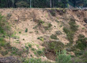
Traces of dunes at a relatively high altitude and distant form the coastal area
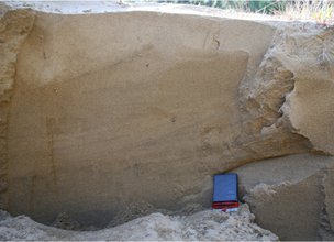
The Local Natural Monument corresponds to the NE side of the Galeão massif (57 ha), located on the left bank of the mouth of the Lima River. In this area, three flattening surfaces are preserved: Vila Fria Surface (50 m), Ola Surface (75 m) and Faro de Anha Surface (100 m) (Carvalhido, 2012; Carvalhido, 2014a, 2014b, 2014c). These surfaces are regularized by sandy deposits, well calibrated, preserving interlaced stratification and cross lamination by current ripples (Carvalhido, 2012, 2014a, 2014b, 2014c, 2014d).
The Areias de Galeão are dune sands deposited at the culmination of the climate crisis of the Little Ice Age (Dalton Minimum) (radiometric dating indicates deposition between the years 1780 and 1800). The typical criss-cross stratification of this unit is clear in some sectors, although sometimes only low-angle beams are observed (Carvalhido, 2012, 2014d). The morphometry and morphoscopy data prove the aeolic origin of the deposits, consisting of grains from rolled to sub-rolled features, with perforated and shiny rounded surfaces. The low humidity conditions, associated with the strong winds that would have been felt during the Dalton Minimum, will have been responsible for the transport and subsequent wind regulation of the Galeão surfaces. Despite the carbonated content of Areias de Galeão, the recent age, the weak thickness of the deposits and the cold conditions (conducive to the dissolution of carbonates) will have prevented their consolidation. Parish memories are an asset with potential for exploring this theme (e.g. disappearance of the parish of Aster under the dune sands). The base of the Areias de Galeão unit (first 20 cm) conserves medium to fine granite clasts, of two micas and biotitic (MPS = 20 cm), subangular (Carvalhido, 2012).
Under the dune sands there is the lithostratigraphic unit Areias da Ribeira da Areia, which corresponds to the water availability conditions that precede the Maunder Minimum, which constitutes the period of full installation of the Little Ice Age in Europe. The standard deposits retain some of the sets of frontal ripples with preserved internal structure - tangential to sigmoidal frontal blades, inclined towards NE and dorsal counterflow blades. The OSL dating of the deposits revealed installation between the years 1590 to 1650 (Carvalhido, 2012, 2014c).
The available radiometric data, the stratigraphic contact in involution and the decacentimetric clasts of medium grain granite, of 2 micas, angular, in the transition between the two levels, allow to deduce the association of the deposits with climatic evolution until the installation of the Maunder Minimum: the lower level is associated with a medium with available liquid water, associated with currents (Areias da Ribeira da Areia), to degrade the wind deposits at higher levels, later transitioning to cold conditions (signs of cryoturbation in the transition between both units), strong winds but not very humid (Maunder Minimum) (Areias de Galeão) (Carvalhido, 2012).
References:
Carvalhido (2012). O Litoral Norte de Portugal (Minho-Neiva): evolução paleoambiental quaternária e proposta de conservação do património geomorfológico. Tese de Doutoramento, Universidade do Minho, 564 p.
Carvalhido, R.; Pereira, D. & Cunha, P. (2014a) – Depósitos costeiros quaternários do noroeste de Portugal (Minho - Neiva): caracterização datação e interpretação paleoambiental. Comunicações Geológicas (2014) 101, Especial II, 605–609.
Carvalhido, R.; Brilha, J. & Pereira, D. (2014b) – Monumentos Naturais Locais de Viana do Castelo: processo de classificação e estratégias de valorização. Comunicações Geológicas (2014) 101, Especial III, 1219–1223.
Carvalhido, R.; Pereira, D; Cunha, P.; Buylaert, J. & Murray, A. (2014c) Characterization and dating of coastal deposits of NW Portugal (Minho-Neiva area): a record of climate, eustasy and crustal uplift during the Quaternary. Quat Int, 328-329: 94–106

Location
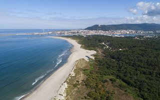
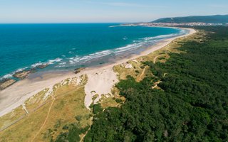
On the Galeão massif, located on the left bank of the mouth of Lima, in the parishes of Darque and Vila Nova de Anha
Coordinates
Lat: 41.6775338
Long: -8.8030725
 Theme
Theme
 Point of interest
Themes
Discover all the themes of Climbing Dunes in Faro de Anha

Ecological Recovery
The following proposal was presented by the Mayor of the Chamber:- "PROPOSAL - Cooperation Protocol within the scope of the Progama de Reabilitação de Áreas Classificadas do concelho de Viana do Castelo - Responsabilidade ambiental no âmbito das áreas classificadas do concelho de Viana do Castelo".
In the scope of the Municipal Strategy for Nature Conservation, a plan inscribed in the ongoing Environment and Biodiversity Agenda for the four-year period 2017-2021, the Municipality prepared the Programa de Reabilitação Ecológica das Áreas Classificadas do concelho, in this first phase, focusing on 5 of the 13 Natural Monuments, unique areas for the knowledge of the geological history of the Iberian Peninsula since more than 500 million years ago and which are part of the application that the Municipality is preparing for recognition as a UNESCO World Geopark territory. Viana do Castelo is a rich territory from the point of view of Natural and Cultural Heritage, with about 4,800 hectares specifically designated for the protection of fauna and flora habitats (3 sites of Community importance of Natura 2000 Network), being the only municipality in the country with the geological heritage inventory concluded and duly classified with 13 natural monuments, making up a total area of about 2,832 hectares. The recovery programme that was drawn up supported an application to PO SEUR, with approval of the overall investment amount of 500,000 euros, financed at 85%, with implementation in 2020 and 2021. The ecological recovery interventions that are intended to be carried out include actions to eradicate and control exotic species, mainly Acacia dealbata (Mimosa), Acacia longifolia (Acacia longifolia) and Acacia Melanoxylon (Australia), Carpobrotus edulis (beach weevil), Arundo donax (giant reed), Trandescantia fluminencis (Fortune grass or tradescância) and Cortaderia selloana (pampas grass or plumas). In addition to these actions, supported by an exhaustive inventory carried out by the Municipality for those species, the programme includes actions to promote scientific literacy to the population and the densification of the Municipality's Citizen Science strategy, extending the Bioregisto platform to the cartography of invasive vegetation, in collaboration with the Functional Ecology Centre of the University of Coimbra (invasoras.pt). In addition, planting actions are planned in the areas to be ecologically intervened, namely native species such as oak, pine, hawthorn, holm oak, birch or heather, among others, within the scope of the Municipal Year for the Recovery of Portuguese Native Forests, currently underway. In order to guarantee the perennial success of the intervention and the investment made, the rehabilitation programme foresees the involvement of the social and business fabric, and within the scope of the environmental responsibility of the institutions, so that they may take responsibility for the maintenance of the ecological quality of all or parts of the classified areas of the municipality of Viana do Castelo. The programme for the ecological rehabilitation of the classified areas of Viana do Castelo - 1st phase - was carried out with the collaboration of the Parish Councils of Afife, Carreço, Darque, Vila Nova de Anha and Santa Marta de Portuzelo, and also with the Parish Councils of Mazaferes and Vila Fria and the Parish Councils of Viana do Castelo (Santa Maria Maior and Monserrate) and Meadela. The Associação de Caçadores de Vila Nova de Anha and the Comissão Diretiva dos Baldios da Montaria were also partners.


Hello little one!
I'm Piquinhos and I can help you learn more about the Geopark!

Technical details
Child Mode
Discover the geopark in a simpler format, aimed at the little ones.
Clique ENTER para pesquisar ou ESC para sair