
The differential fit of Lima
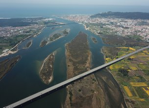
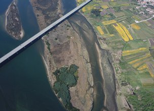
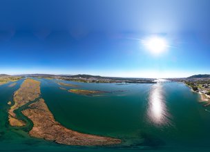
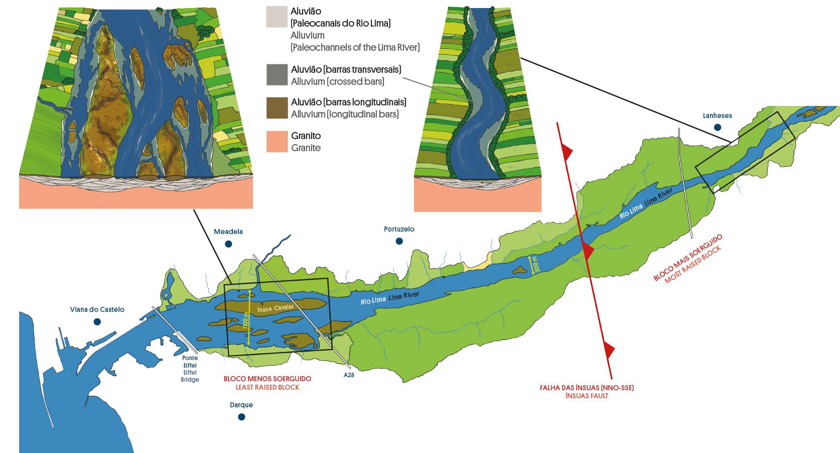
The Lima River, in its 108 km of extension, has in the last 23 km a reduced inclination called Ribeira Lima downstream of Ponte de Lima. It never exceeds 300 metres wide until Serreleis/Cardielos and with a sinuous but wide layout that keeps up to about 6 km from the river mouth, from those villages the Lima River widens to more than 1 km between riverbanks.
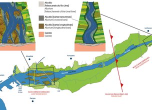
The width of the lower estuary with joined channels separated by longitudinal bars - the “ínsuas” - is due to the existence of a fault (NNW-SSE) - the “ínsuas” fault - which would have allowed the inner block (east) to be higher than the mouth block (west) by the forces that have been at work for 180 million years and which were responsible for the orography of Europe and North Africa, such as the Alps, the Pyrenees or the Atlas.
The lower estuary of the Lima River, has several longitudinal bars, the largest, the “Ínsua Cavalar”, is 2 km long and has an area of approximately 50 ha. It was from here that in 1913 a motorized aeroplane, the “Blériot XI”, built by the talented mechanical engineer from Vienna, João Branco and piloted by Norberto Gonçalves, took off to the skies.
References:
Carvalhido (2012). O Litoral Norte de Portugal (Minho-Neiva): evolução paleoambiental quaternária e proposta de conservação do património geomorfológico. Tese de Doutoramento, Universidade do Minho, 560 p.
Carvalhido (2014). Processo de classificação dos 5 Monumentos Naturais Locais de Viana do Castelo. Memória Descritiva. Câmara Municipal de Viana do Castelo.
Carvalhido (2018). Livro de Pedra, Monumentos Naturais Locais de Viana do Castelo – Catálogo. Câmara Municipal de Viana do Castelo, 2ª edição.
The Lima River, in its 108 km of extension, has in the last 23 km a reduced inclination called Ribeira Lima downstream of Ponte de Lima. It never exceeds 300 metres wide until Serreleis/Cardielos and with a sinuous but wide layout that keeps up to about 6 km from the river mouth, from those villages the Lima River widens to more than 1 km between riverbanks.
The width of the lower estuary with joined channels separated by longitudinal bars - the “ínsuas” - is due to the existence of a fault (NNW-SSE) - the “ínsuas” fault - which would have allowed the inner block (east) to be higher than the mouth block (west) by the forces that have been at work for 180 million years and which were responsible for the orography of Europe and North Africa, such as the Alps, the Pyrenees or the Atlas.
The lower estuary of the Lima River, has several longitudinal bars, the largest, the “Ínsua Cavalar”, is 2 km long and has an area of approximately 50 ha. It was from here that in 1913 a motorized aeroplane, the “Blériot XI”, built by the talented mechanical engineer from Vienna, João Branco and piloted by Norberto Gonçalves, took off to the skies.
References:
Carvalhido (2012). O Litoral Norte de Portugal (Minho-Neiva): evolução paleoambiental quaternária e proposta de conservação do património geomorfológico. Tese de Doutoramento, Universidade do Minho, 560 p.
Carvalhido (2014). Processo de classificação dos 5 Monumentos Naturais Locais de Viana do Castelo. Memória Descritiva. Câmara Municipal de Viana do Castelo.
Carvalhido (2018). Livro de Pedra, Monumentos Naturais Locais de Viana do Castelo – Catálogo. Câmara Municipal de Viana do Castelo, 2ª edição.

Exemplary schemes of the Lima islands
Location
Meadela
Coordinates
Lat: 41.697273
Long: -8.807075
 Theme
Theme
 Point of interest

Hello little one!
I'm Piquinhos and I can help you learn more about the Geopark!

Technical details
Lima differential fit
The study of the evolution of the relief of the Viana do Castelo coast, carried out by Carvalhido R. (2012), allowed to classify several structural alignments, among them the active alignment (probable fault), essentially with the opposite behavior, of the structural discontinuity of Seixas-Vila Cold NNW-SSE and that constitutes the Ínsuas fault. This classification was obtained because it is associated with larger-scale geomorphological aspects, such as compartment and block tectonics. This alignment with moderate seismic activity, between 3.6 and 4.6 degrees on the Richter scale, associated with 5 events between 1909 and 1960, is responsible for the changes in the fitting of the Lima valley, which becomes very wide, ensuring the maintenance of the longitudinal bars (intrinsic) characteristics that are downstream of this discontinuity.
Referências Bibliográficas:
Carvalhido (2012). O Litoral Norte de Portugal (Minho-Neiva): evolução paleoambiental quaternária e proposta de conservação do património geomorfológico. Tese de Doutoramento, Universidade do Minho, 560 p.
Carvalhido (2014). Processo de classificação dos 5 Monumentos Naturais Locais de Viana do Castelo. Memória Descritiva. Câmara Municipal de Viana do Castelo.
Carvalhido (2018). Livro de Pedra, Monumentos Naturais Locais de Viana do Castelo – Catálogo. Câmara Municipal de Viana do Castelo, 2ª edição.
Exemplary schemes of the Lima islands
Child Mode
Discover the geopark in a simpler format, aimed at the little ones.
Clique ENTER para pesquisar ou ESC para sair