
Salt Pans
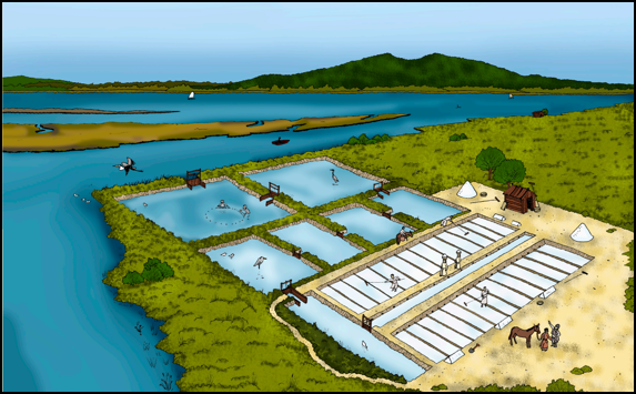
The salt pans are a complex system of reservoirs (plots), channels and tanks for the decantation and evaporation of salty water. They are separated by dykes and slopes colonized by typical marsh vegetation, for the extraction of salt.
The lower estuary of the Lima River is a wide depression, with easily flooded river banks although with different frequency. Running the Lima River embedded in the Lima fault (ENE-WSW), its banks have different reference altitudes: to the north, higher (2.6 to 3 m above sea level) where the salt pans of Meadela are found, and to the south, lower (0.1 to 2.3 m above sea level) where the salt pans of Darque are found. It is precisely for this reason that the wetlands S. Simão and the lagoons of Vila Franca appear on this shore, and the salt production is less important than on the northern shore, as it is more difficult to guarantee the necessary conditions for water evaporation.
The Lima River estuary, was considered the “largest salt center of the Minho coast”. Salt being one of the most precious goods, “it was of great importance to own salt pans, which even reached prohibitive prices, as is the case of two plots in Darque that were exchanged in 1085 for a mare.
References:
Almeida, C. B. (2005). A exploração do sal na costa portuguesa a Norte do Rio Ave. In: Da Antiguidade Clássica à Baixa Idade Média. Actas do I Seminário Internacional sobre o sal português. Instituto de História Moderna da Universidade do Porto, Porto, p. 137-170
Carvalhido (2012). O Litoral Norte de Portugal (Minho-Neiva): evolução paleoambiental quaternária e proposta de conservação do património geomorfológico. Tese de Doutoramento, Universidade do Minho, 560 p.

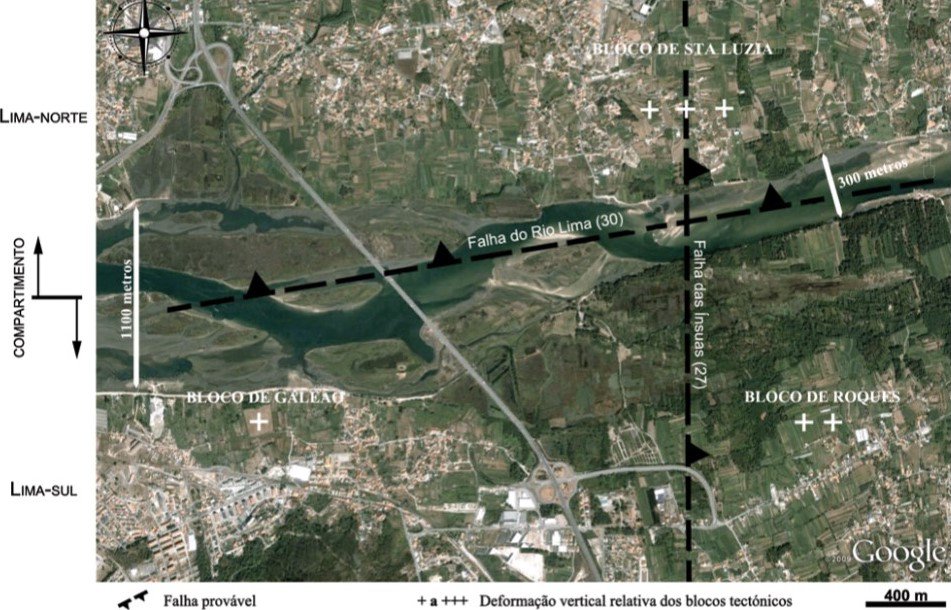
Scheme of Ínsuas Islands' faults
Location
Meadela
Coordinates
Lat: 41.698186
Long: -8.801968
 Theme
Theme
 Point of interest

Hello little one!
I'm Piquinhos and I can help you learn more about the Geopark!

Technical details
Salt pans
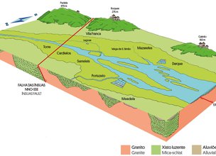
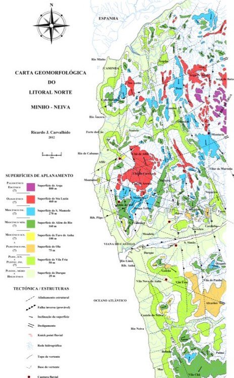
The study of the evolution of the relief of the Viana do Castelo coast, carried out by Carvalhido R. (2012), allowed to classify several structural alignments (Fig. 1), among them the active alignment (probable fault), essentially with the opposite behavior, the discontinuity of the ENE-WSW Lima and which constitutes the Lima fault. This classification was obtained because it is associated with larger-scale geomorphological aspects, such as compartment and block tectonics. This alignment is responsible for a depressed or less elevated area, on the south bank of Lima compared to the north bank. It has preserved about twice the alluvial area, alluvial terraces, the presence of wetlands of greater extension (e.g. Wetlands of S. Simão) and with lower levels compared to the depressed areas to the north (e.g. Saltpans of Meadela) thus allowing the production of salt to be of greater relevance on the north bank.
References and scientific articles
Almeida, C. B. (2005). A exploração do sal na costa portuguesa a Norte do Rio Ave. In: Da Antiguidade Clássica à Baixa Idade Média. Actas do I Seminário Internacional sobre o sal português. Instituto de História Moderna da Universidade do Porto, Porto, p. 137-170
Carvalhido (2012). O Litoral Norte de Portugal (Minho-Neiva): evolução paleoambiental quaternária e proposta de conservação do património geomorfológico. Tese de Doutoramento, Universidade do Minho, 560 p.
Scheme of Ínsuas Islands' faults
Child Mode
Discover the geopark in a simpler format, aimed at the little ones.
Clique ENTER para pesquisar ou ESC para sair