
Climatic cycles
This area of the Natural Monument of Pedras Ruivas preserves testimonies of how the last and current climate cycle evolved, namely sediments, fossils, coastal platforms and larger scale geoforms.
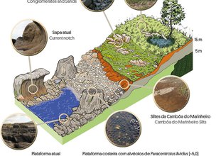
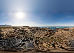
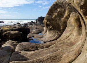
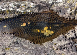
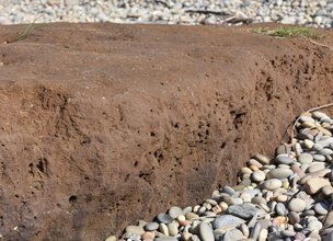
Despite the cliffs that dominate the landscape is organized in a very choppy way, as a result of the abrasion on the very dense fracture network, some stand out whose tops, flattened at an altitude of 5 m, reveal an ancestral beach level, from the last interglacial, outside the reach of the current sea. This origin is certified by the ichnofossils of Paracentrotus lividus, sea urchin housing cavities, organisms tolerant to rapid variation in abiotic conditions such as salinity, partial pressure of oxygen and temperature resulting from a tidal cycle, but without resistance to desiccation. Therefore, the marine occupation of these levels is determined, 125 thousand years ago, at a time when the sea level would be about 20 cm above the current. The difference of about 4.8 m observed is explained by seismic crises, a subject developed in the Natural Monument Alcantilado de Montedor.
From the climatic evolution that followed, from climatic cooling to glaciation, the lake sediments that constitute one of the layers of sediments that cover the coastal platform up to the water line, which are dark brown, are preserved and witnessed. This sedimentary unit was deposited in depressions of the ancestral coastal platforms, with reduced depth, between 18000 and 11000 years ago, forming an environment of a swampy lagoon. This lagoon lasted in the landscape for about 7 thousand years and would be supplied by spring melting waters from the snows of the local slopes. From microscopic data, pollens and spores of freshwater algae were identified, which prove the existence of a confined environment away from direct marine influence.
This area of the Natural Monument of Pedras Ruivas preserves testimonies of how the last and current climate cycle evolved, namely sediments, fossils, coastal platforms and larger scale geoforms.
Despite the cliffs that dominate the landscape is organized in a very choppy way, as a result of the abrasion on the very dense fracture network, some stand out whose tops, flattened at an altitude of 5 m, reveal an ancestral beach level, from the last interglacial, outside the reach of the current sea. This origin is certified by the ichnofossils of Paracentrotus lividus, sea urchin housing cavities, organisms tolerant to rapid variation in abiotic conditions such as salinity, partial pressure of oxygen and temperature resulting from a tidal cycle, but without resistance to desiccation. Therefore, the marine occupation of these levels is determined, 125 thousand years ago, at a time when the sea level would be about 20 cm above the current. The difference of about 4.8 m observed is explained by seismic crises, a subject developed in the Natural Monument Alcantilado de Montedor.
From the climatic evolution that followed, from climatic cooling to glaciation, the lake sediments that constitute one of the layers of sediments that cover the coastal platform up to the water line, which are dark brown, are preserved and witnessed. This sedimentary unit was deposited in depressions of the ancestral coastal platforms, with reduced depth, between 18000 and 11000 years ago, forming an environment of a swampy lagoon. This lagoon lasted in the landscape for about 7 thousand years and would be supplied by spring melting waters from the snows of the local slopes. From microscopic data, pollens and spores of freshwater algae were identified, which prove the existence of a confined environment away from direct marine influence.

Coastal platforms
Location
Praia Norte
Coordinates
Lat: 41.7009519
Long: -8.8568259
 Theme
Theme
 Point of interest

Hello little one!
I'm Piquinhos and I can help you learn more about the Geopark!

Technical details
THE RISES AND DOWNS OF THE ATLANTIC
The knowledge of sea level changes is essential for understanding the quaternary evolution of sedimentary environments, since these disturbances influence the characteristics of the processes that determine the supply and distribution of particles.
The Darque Surface has several types of continental and transitional sediments, which document paleoenvironmental conditions that varied between MIS9 (340ka) and MIS1 (present).
Sedimentary units identified in this natural monument reproduce evidence of the environments at your deposition:
- The Cambôa do Marinheiro silts, dated below 20 ka and up to about 13 ka (most recent date obtained) (MIS2), show that sedimentary processes have become essentially dependent on drainage in conditions of greater water scarcity, which indicate the progression and peak of the installation of the cold conditions resulting from the last glaciation. The conditions of diffuse drainage will have contributed to the formation of lacustrine bodies of high confinement, of swampy character, installed in shallow depressions of the Coastal Platform.
- The Conglomerates and Sands of Rego de Fontes correspond to the installation of depositional means with some variability of facies, with dating of <13 ka (MIS2 / 1). In general, the character of episodic water availability is observed, namely represented in drainage under low granoselective regimes, sometimes torrential (grain-flow to debrisflow), evolving to facies associated with soaked soils responsible for solifluction processes.
References and scientific articles
Carvalhido, R. (2012). O Litoral Norte de Portugal (Minho-Neiva): evolução paleoambiental quaternária e proposta de conservação do património geomorfológico. Universidade do Minho.
Coastal platforms
Child Mode
Discover the geopark in a simpler format, aimed at the little ones.
Clique ENTER para pesquisar ou ESC para sair